
 龙软天下
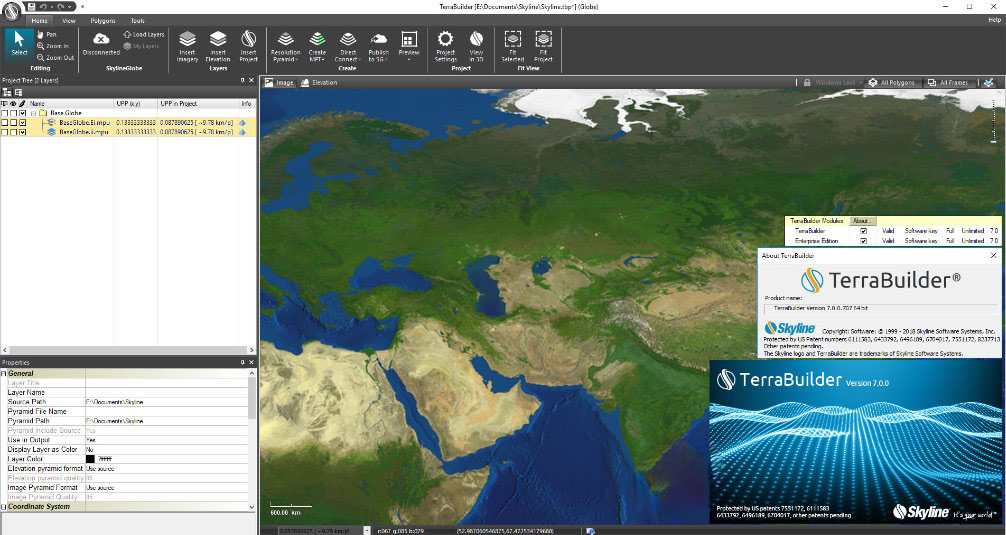
龙软天下Skyline TerraBuilder Enterprise 是一个基于陆地的3D数据库构建器,具有管理和集成航空照片,卫星图像和各种尺寸和分辨率的数字高程模型的专业工具。 因此,可以向当地TerraExplorer客户或远程客户(使用SkylineGlobe Terrain服务)发布逼真的图像,地理信息和准确的地形数据库。
Skyline TerraBuilder Enterprise 互通性支持多种图层类型,灵活的层操作编辑工具的范围,以实现最高精度,高性能高效的地形创建过程,近实时更新使用DirectConnect避免耗时的重新创建完整的MPT文件,高效的数据管理管理和共享整个组织的企业信息。
TerraBuilder 功能特性:
>加载本地和远程文件
>支持各种格式
>动态插件机制,可以从Skyline轻松安装更新的插件
>使用不同坐标系的图层自动重投影
>轻松裁剪,调整大小和移动图层
>使用关联点调整地理坐标
>调整颜色和高程参数
>使用剪辑,排除和填充多边形以便于编辑
>在多个图层上同时执行多边形操作
>多边形羽化
>预览模式 – 允许您在启动MPT文件创建之前预览和纠正可能存在问题的区域
>使用网络融合可显着缩短处理时间
>自动创建源分辨率金字塔
>支持多核和多计算机处理以加速海量数据集发布
>通过引用原生格式的预处理优化版源来优化DirectConnect项目
>支持多核和多计算机处理以加速海量数据集发布
>使用SkylineGlobe服务器将未处理的地形数据库提供给远程TerraExplorer Pro和WMS客户端
>通过查询和搜索发布到SG Server的所有数据层来查找最新的地理数据。
TerraBuilder is a 3D land-based database builder with professional tools for managing and integrating aerial photos, satellite images, and digital elevation models in various dimensions and resolutions. As a result, realistic imagery, geographic information, and accurate terrain database can be published for local TerraExplorer customers or for remote customers (using SkylineGlobe Terrain service).
TerraBuilder provides professional-grade tools for manipulating and merging aerial photos, satellite images, and digital elevation models of different sizes and resolutions. The resulting photo-realistic, geographically accurate terrain database can be made available to local TerraExplorer clients or published directly from TerraBuilder to SkylineGlobe Server for serving to remote TerraExplorer and WMS/WMTS clients.
Features and Features of Skyline TerraBuilder Software:
- Adjust the color and height parameters
- Set geographic coordinates using points
- Crop, resize and change layers easily
- Simultaneous polygon operation on different layers
- Use clip, delete, and polygon fill for easy editing
- Plugin Dynamic Compatibility for easy installation of upgraded plugins from Skyline
- Preview Mode – Allows you to preview and modify problem areas before you start creating MPT files
软件下载地址:
Skyline TerraBuilder Enterprise 7.2.0 注册版 – 3D地形数据库
Download 城通网盘:https://url65.ctfile.com/f/3477565-986530591-601f2a?p=6871 (访问密码: 6871)
Download 百度网盘:
解压密码:www.atvnk.com


评论前必须登录!
立即登录 注册本站